Sunday, February 24, 2008

Day 4, part one. Wildrose.

So, rumor has it that no one actually reads what I write. So I'll keep the words on this one to a minimum.

Ya wanna Television? Telephone? AND watah ya can drink? Ya ain't from around here, is ya?

Headquarters at Stovepipe Wells. Basic. I like it that way.

I woke up early in the morning; the plan being to go from below sea level, up to Wildrose, where the climb stops just above 8100 feet. Round trip: 80 miles.

Route

Start of the day, in what is loosely referred to as the 'town' of Stovepipe Wells.


I rode down the hill until I was at least three feet (minimum!) below sea level, and turned around to make it back up.

Unlike... well pretty much every climb I'd ever been on, this one really didn't have any switchbacks - it just, slowly and steadily, went up a lumbering mountainside.

2000 Feet

Fortunately the state of California put up signs indicating altitude every 1000 feet; Sea Level, 1000 feet, 2000 feet... what comes next? Oh wait, nothing. Man, I thought I'd have a great montage of pictures indicating altitude, but they stopped.


Some rocks. There were a lot of them.


Oh, so *now* you give me the elevation?

Random peak along the way.

At about 6000 feet, the road turned to gravel.

Charcoal Kilns, at about 7500 feet above sea level.

These charcoal kilns are considered some of the best preserved anywhere, having been only used for a year or two before being abandoned. Gee, who wouldn't walk 100 miles across several mountains and a desert for a good deal on a bag of Charbroil? Who the hell is tailgating in the middle of a desert, anyway? What are they grilling? Who's bringing the beer?

Questions that, perhaps, the owners of the kilns should have considered before construction.

Keeping track of where we've been.

Unfortunately, I didn't get all the way to the top; at about 8000 feet, the mud road turned to ice. Contrary to my usual lack-of-decision-making-ability, I did the intelligent thing, and turned around.

The long and winding road...


Looking down...

And started the godawful descent.

Day 3, part 3. Death Valley Road.

Abandon all hope, ye who enter here.


So after my fun trip down Pine Creek, I headed east to Death Valley.

You see, what makes the Sierra Nevada so snowy is that they block the clouds - as the clouds rise to pass over the Nevada, they cool down, and the air cannot support the moisture any more. So all the snow comes out.

And nothing is left for Death Valley. Bad for prospectors. Good for winter cyclists. Assuming you don't need any extra water.

No, I distinctly remember telling you to bring the water.


The Road starts off in the middle of nowhere, and goes nowhere. But at least the altitude changes; it starts off at 3643 ft and goes to 7670 in about 14 miles. My plan was to go to the top, descend the other side (another 14 miles), then return, for a grand total of about 56 miles.

Desolate.

That's really the only way to explain it. No cars, no people. No nothing. I ascend to the top, where there are no signs congratulating you for reaching the summit.

The Top. We hope you know where you are, because, well, we hate signs.


I descend the other side... still nothing. After an hour of descending, I turn around, climb, and descend again.

Desolation.


I get in my car. Another two hours of driving in Death Valley, and I'll reach my headquarters for the next few days.

Day 3, part 2. Pine Creek Road.

I like this picture.


Now, as alluded to previously, most of the roads in the Sierra Nevada are closed in the winter.


But not all of them.

Pine Creek Road is a little road that starts just North of Bishop, CA. It climbs past about forty mining-company-owned-houses in a far-too-perfect-to-be-natural grid, and goes up to the mine. The company keeps the road cleared year round.

Start of the climb.

Now, this road wasn't without it's drawbacks. But traffic? I saw one abandoned car in the two-hour climb. No other souls.

My Destination.

Obligatory switch-back photo.

This was a quick climb, only about an hour to get from the valley floor (at about 4000 feet) to the top (at just 7750 feet). So I only got an hour of fun... before the torture began.

The descent.

You see, at the base of the climb, it's 60 degrees and Sunny, and you work as hard as you can. When you start the descent, well, now you're at altitude, it's 30 degrees and you're going over 40 MPH down the hill... on this one I was going ~48.

The Descent.

You can't pedal fast enough to get any resistance. All of the sudden you aren't working at all, you're soaked with sweat, it's 30 degrees, and you have a 50 MPH headwind. "The cold skips all kinds of phases"... You're instantly frozen throughout your entire body. I stop several times to warm up. Seeing the end of a descent is a weight off your shoulders... finally, get back in the car to warm up.


And drive to the next climb.

Day 3, part 1. Bishop, CA

'Wait a second', you say. 'I thought you were in Livermore on Monday the 11th, which would've been the Day 3?!?'.

My response: My blog, my rules.


So after the presentation on Monday (which will be the subject of it's own blog entry in a week or two (hint hint...)), I was actually a little worried - after two days of riding hard almost five hours a day, stopping can put your body into a coma. Nevertheless, I had already reserved a room in the little town of Bishop, CA - which was right at the base of some of the few climbs that weren't closed by six feet of snow.

An aside - Sierra Nevada literally translates to 'Snowy Mountains', and is home to the highest snowfalls in the contiguous US. I was aware of that, but not fully cognizant, as will soon be seen.

In any case, the five hour drive had the added benefit of about two hours driving through Yosemite; which I was looking forward to.

It's good to have a plan.


Now, plenty of people are cyclists in California, including some of the people to whom I was presenting. So when I enquired about how long it would take to get to Bishop, I was rather surprised when the response started with 'Well, this time of the year...'. Uh, what do you mean, *this* time of year?


Yosemite was closed. Closed. As in, we don't even try to keep it open, it's just not worth the effort. Wow.

And Bucknuts.

OK, no problem. Still 5:00 PM, and the hotel had a cancellation policy of 6:00 PM; I'd just go south - way south - to a cleared highway to make it over the mountains. I called the hotel. 'Oh... this was booked through Travelocity... you'll have to call them.'

I called Travelocity. Or, more accurately, I called their voice-recognition computer answering machine. They apparently got it on sale at Wal-Mart.

"Please state the name of the city in which you are staying".
"bishop, california".
"...Please wait... ...Beijing, China. Is this correct?"
"NO."
"Please repeat the name of the city in which you are staying".
"Bishop, California".
"...Please wait.... ...We're still pretty sure you said Beijing, China."
"$%^&*&#, I said BISHOP, CALIFORNIA"

After about five minutes of screaming "Bishop, California" into a voice-recognition system designed by heavily-accented software engineers with a very twisted sense of humor, I actually managed to talk to a real person.

"...Oh, I'm sorry, that reservation is for today. We can cancel it, but we won't refund your money."

Come again?

OK, Travelocity, now it's on. I will get to Bishop just to spite you.

I call the hotel again. I ask him how to get there, IN THE WINTER. He goes down the list...

"Highway XXX... oh wait, that's closed."
"Highway YYY... oh wait, that's closed."
"Highway ZZZ... oh wait, that's closed."


He finally gives me a route.


I love it when a plan comes together.


Before I leave Livermore, I stop at a grocery store. I pick up a week's worth of food in pre-packaged form... mostly energy bars. Eight gallons of distilled water (Many facilities in Death Valley don't have potable water). And a two-foot long extra wide sub sandwich, ostensibly meant for a family or a small festival.

Or me.

...and off I go. The last glimpses of sunlight cease. I stop for fuel. My headlights gradually start to illuminate different flora on the side of the road...

Grass yields to weeds.
Weeds yield to dirt.
Dirt yields to rocks.

Through the window, I see the Milky Way. I stop and turn off my headlights. I get out of the car, in awe of the stars. As far as the eye can see, there is no sign of life... no headlights, no town, no gas station, no street lights.

Hours later, in the middle of the night, I arrive in Bishop. All the lights are out; I have to wake the innkeeper. I stumble into bed.


The next morning the sun peeks in through the windowshade. I look out.


I'm here.

Day 2. Mt. Tamalpais; very little climbing.

San Francisco, climbing out of the Morning Fog.


So, my tour guide from Day 1 recommended riding Mt. Tamalpais quite highly. Even though it didn't have much climbing, he told me the overall ride would be worth it.

He was absolutely correct.

But let's go back in time a bit, first. My host for the weekend, Gary, had been rattling off a bunch of touristy things to do - tour Alcatraz, see the Golden Gate bridge, yadda, yadda - when I interrupted him and told him I was in California for the cycling. Nothing more. Seeing the room where Al Capone whittled his shiv really had no appeal to me.

So, I mapped out the directions to the start of my ride. Normal looking google directions, nothing special. And then, all of the sudden, I was on the Golden Gate bridge.

Well, check that off the list of ultra-touristy things to do.

On the north side of the Golden Gate, I parked at the side of the road and started what was to be a 4.5 hour journey through some beautiful parks.


Prepping to hang-glide over the Pacific.


Now, granted, there was almost no sustained climbing on Day 2 - the highest elevation I reached was only ~2500 feet; I had to make up for it by climbing it twice. Fortunately I started at sea level.

You call *this* a hill?

At the top was the ubiquitous lookout station... although, quite unexpectedly, it wasn't open to the public! The signs indicated that this was a station to watch for wildfires. Ah, California... I'm not in Michigan any more.

Pacific Coast Highway - a view from above.

Once again, I was treated to some beautiful, beautiful vistas. I climbed the mountain from the south, went down the North side ridge onto the Pacific Coast Highway. Although the wind was terrible, the winding roads made up for the effort; they led me to a quaint, hidden little town, where I stopped at the General Store (really!) and bought some food for lunch.

I went back up the North side of the Mountain, stopped for some pictures, and headed out to Livermore to prepare for my presentation on Monday.

Another day, another dollar.

Day 1 in California - Mt. Diablo.

Day 1. Madness and Mayhem in San Francisco.

Unfortunately, the climbing wasn't so much.

So, as many of you are aware, Ford sent me to Livermore (outside of San Francisco ) this past week. I took the opportunity to take a few vacation days, and shipped my bike out there ahead of time to my friend Gary, who is out there programming video games for the US Army.

I arrived on Friday, and enjoyed some of Gary's hospitality. On Saturday morning, aided by a time change, I set out early to do a nice 80 mile ride, culminating in an ascent of local Mt. Diablo; which had been recommended to me by some kind folks on the intrawebbiez. Gary printed out the turn-by-turn directions for me, and I began my journey.

Now, turn-by-turn directions aren't always the best. First off, the page gets immediately drenched in sweat; second, sometimes what's listed on your directions as 'Mt. Diablo Road' in actuality is labeled either 'State Route 666' or has no sign at all. So when, about two hours into the workout, I stopped to fix a slipping seatpost, I was passed by a local cyclist, I got a little hopeful. After a minute or two I got on the bike, and turned on the afterburners to catch him.

Fortuitous - he was headed to Mt. Diablo as well. Say goodbye to sopping wet wrong directions; say hello to the tour guide.

He was initially heading slower than I would've liked, but I figured that was a small price to pay for not having to hassle with the 'am I going the right way?' thoughts. He explained that this area was usually pretty dry - which explained the almost complete lack of trees - but had recently seen an inordinate amount of rain, which explained the beautiful, rolling hills; meadow after meadow.

I apologize for the over-exposure.


More Meadows.

After about another hour or so of cycling through some of the most picturesque scenes I'd laid my eyes upon, we started up Mt. Diablo. Unfortunately (for me), my blood sugar was now pretty dangerously low, and now I had trouble keeping up with him. The actual climb wasn't very long, though; only about an hour. I went to the top of a lookout tower and was treated to what allegedly was one of the largest fields of view in the world. One hundred and twenty miles to the east, I could see the towering Sierra ranges; and eighty miles or so to the west, I could see the Pacific ocean.

View from the top; the snow-capped Sierra's are a 'brighter' white on the horizon.

Tuesday, February 19, 2008

Death Valley. A history.

Satellite View of Death Valley. Yes, it's strange there.
So, in 1849, there was an influx of gold-crazy emigrants to California. Some of the emigrants - like the Donner party the year before - got to Salt Lake City a little late.

With the late start (always a good idea when traversing 10,000 foot passes) they decided to forgo the Donner route, instead taking a route that basically ran through Mexico.

Albeit late, they were also an impatient lot, and halfway through the trip they decided that going that far south from Salt Lake City was taking too long. One man had a map; it showed there could be a 500 mile shortcut by cutting across Death Valley, (or as it was listed on his map, “Garden of Eden Valley, where the going is easy, there's plenty of water, and the oxen graze freely upon the plains’).

Not surprisingly, the victi… I mean the pioneers had a rough time. Canyons, mountains, no food and little water for them or their oxen… and then, one night, the man with the map decided he’d had enough of the scowls and jokes at his expense (for example, “Knock Knock” "Who’s there?" "Someone with a rope to hang the guy with the map."). Needless to say, humor wasn’t the strong point of early Californians; it would take another 130 years before they would invent the movie "Airplane". In any case the guy who's idea it was to go through Death Valley decided it would be best if he went on to California by himself, and took the only map with him.

The thing about death valley – the thing that keeps the clouds/rain/water from reaching the valley – is that 8,000 to 14,000 foot mountains tower along all sides of it. After entering the valley, there was no way the wagons could leave. When two months had passed without finding a decent source of food or water for themselves or their oxen, the exhausted emigrants decided to hike out of the valley. They burned their wagons and furniture to make beef jerky out of their withered oxen (the oxen did not have a vote in the matter, much to the chagrin of the fledgling Sierra club).

And of course, this brought the realization that the worst tragedy of the journey was before them.

The guy with the map also had all the Teriyaki seasoning.

Monday, February 18, 2008

Results

So, the results of the test? At least read the story about the tent first.

After a few tests, the principal investigator told me my VO2 – a measure of how well your body processes oxygen, and a dominating factor in how well you do in endurance sports.

So what’s a good number? Floyd Landis (winner of the 2006 Tour de France) tested at 90. So did Greg Lemond (1986, 1989, and 1990). Lance Armstrong only tested at about 82 – but in an incredibly odd twist of body chemistry (in other words, the guy is a genetic freak), his body basically doesn’t accumulate lactic acid.

I waited with baited breath. My result? He said “58”.

I groaned. He looked surprised at my reaction, and told me that 58 really wasn’t that bad (later tests had me in the low 60’s).

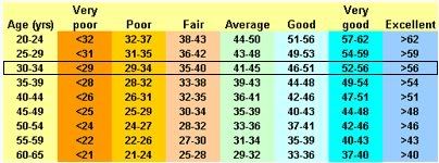
So I looked up what the average person is.

VO2


Wait a second. I’m off the chart. Hmm. And the test normalizes by weight, which basically means that at race weight I’ll be in the high 60’s or maybe, if I train well, the low 70’s.

So then I looked at the next chart.


Professional Endurance Athletes

Hm. So right now I'm below average, and hopefully I can get to average by the end of summer. Not bad for before the altitude test, I thought.


So what about my power output? Before the test, it peaked at 396 watts.
Allen and Coggan's Power Output Chart; widely discredited.

...which I was pretty happy with, too.

So then, after a week in the tent, these numbers went way up, right? Unfortunately, no. I caught a bit of a bug about halfway through the week, and only put out ~365 watts (while trying not to get nauseous) in the post-test. So the month's worth of testing was invalidated.


But I'm still happy.

Day 2. Mt. Tamalpais; very little climbing.

San Francisco, climbing out of the Morning Fog.


So, my tour guide from Day 1 recommended riding Mt. Tamalpais quite highly. Even though it didn't have much climbing, he told me the overall ride would be worth it.

He was absolutely correct.

But let's go back in time a bit, first. My host for the weekend, Gary, had been rattling off a bunch of touristy things to do - tour Alcatraz, see the Golden Gate bridge, yadda, yadda - when I interrupted him and told him I was in California for the cycling. Nothing more. Seeing the room where Al Capone whittled his shiv really had no appeal to me.

So, I mapped out the directions to the start of my ride. Normal looking google directions, nothing special. And then, all of the sudden, I was on the Golden Gate bridge.

Well, check that off the list of ultra-touristy things to do.

On the north side of the Golden Gate, I parked at the side of the road and started what was to be a 4.5 hour journey through some beautiful parks.


Prepping to hang-glide over the Pacific.


Now, granted, there was almost no sustained climbing on Day 2 - the highest elevation I reached was only ~2500 feet; I had to make up for it by climbing it twice. Fortunately I started at sea level.

You call *this* a hill?

At the top was the ubiquitous lookout station... although, quite unexpectedly, it wasn't open to the public! The signs indicated that this was a station to watch for wildfires. Ah, California... I'm not in Michigan any more.

Pacific Coast Highway - a view from above.

Once again, I was treated to some beautiful, beautiful vistas. I climbed the mountain from the south, went down the North side ridge onto the Pacific Coast Highway. Although the wind was terrible, the winding roads made up for the effort; they led me to a quaint, hidden little town, where I stopped at the General Store (really!) and bought some food for lunch.

I went back up the North side of the Mountain, stopped for some pictures, and headed out to Livermore to prepare for my presentation on Monday.

Another day, another dollar.

Thursday, February 07, 2008

The Tent.

I know most of the readers of my blog sit at home continually refreshing the page, ignoring thirst, hunger pangs, and various other bodily functions that I won't describe in detail (this is a family blog). You all had read this post, barely remembering to breathe while you anticipated the follow-up. Well, your wishes can come true (and soon you'll be able to take a bathroom break).

After my cycling aptitude had been tested four or five times, I was sent home with an altitude-simulating tent, meant to be installed on my bed. This is the kind of stuff that national-level athletes use, so I was happy to have the chance to try it out and see how it worked.


Somewhere, a US Olympian is getting weaker.

I was a little amused that I was going to be using an altitude tent that an Olympic swimmer had been (and by all rights still should have been) using. But hey, life isn't fair. Or at least it isn't for Olympic hopefuls. For me, things were coming up roses.


Oxygen De-generator.

The basis of the tent - this device takes the oxygen out of the air, simulating altitude. Your body compensates by producing more red blood cells. Basically, you're starving your body of Oxygen while you sleep so that it will more efficiently absorb it while you're working hard.


Camping in my bedroom.

It was a bit of a tough fit to put the matress in the tent. I had to repair a broken tent pole (it was like that when I got it) and managed to break another tent pole (so I started to get pretty good at repairing broken altitude tents, which I'm sure is a marketable skill). After about an hour of wrestling the matress and the tent, I had everything assembled.

Sleeping in the tent? Actually, I slept quite well. The lack of Oxygen made me go unconcious right quick, thank you very much. The second night in the tent, I started bringing in various devices to make my life easier - a flashlight so I could read the pseudo-altimeter, a couple of books, a bottle of water, and on and on... I definitely wouldn't mind sleeping in the tent every night (they make ones that are a little larger, and which are easier to get in and out of), except that this one cost in the neighborhood of $6000.

Too rich for my blood.

And the results? Was I suddenly catapulted from an also-ran into a National Contender?

Tune in next week to find out!

Just remember to breathe while you're waiting.

Sunday, January 27, 2008

Flashbacks of Homeroom

Contrary to popular opinion, there were rare occasions in High School where I actually made it to Homeroom. Not on time, that never happened. But occasionally I would get there before it ended.

At that point, my High School had sold it's soul - or more accurately, was forcing the students to submit to twenty minutes of advertising in order to pay for televisions in the classroom. The same ten commercials would repeat themselves, day after day, until even those of us who skipped homeroom daily were chanting them on the way to first period swimming class (swimming was always scheduled for first period, because school administrators hate students).

Thankfully, the advertising was well controlled so that our young, impressionable minds wouldn't be subjected to the whims of corporate advertisements. For instance, we were inspired to Be Like Mike by chasing dreams of athletic prowess rather than academic achievement, all while drinking gallons of high fructose corn syrup. Sometimes we'd be inspired to follow our own dreams, not to be afraid of being different - like when Van Halen urged us to try Crystal Pepsi. (I think the lesson was that following our own dreams leaves a horrible aftertaste). And lest you think that this is a tirade against nonstop junkfood advertising in the classroom, let me say this: corporate America should be trusted with informing our youth about their nutrional choices. For instance, without those commercials, I never would've learned so much about how Tasty Doritos are when paired with a Pepsi. And, uh, I have good word that Doritos are fried in corn oil.


Corn is *definitely* a vegetable. I think. Sometimes it's tough to pay attention in biology when you're hungry and the vending machine is just outside the door. In any case I know things turned out well, because America's youth is slim and trim.


So what did we, the students whose very youth was bargained away under the guise of education, receive from be subjected to these wares? Television in the classroom. A lofty goal, methinks. I did learn that it's much easier to sleep through a Jets vs. Sharks dance-off than it is to read Shakespeare.

Education for the real world. That's gotta count for something.

Friday, January 25, 2008

Thursday, January 24, 2008

Testing

So in fall of last year, I received an email soliciting my participation in a study to determine the effects of altitude exposure on anaerobic performance.

Being as I spent most of November and December completely exhausted and/or sleeping, I was a little reticent to start the study, but I figured I would honor my commitment. I'm definitely glad I did.

So I started biking again semi-seriously in late December/early January. I've found that I've gotten my energy level back up to snuff. A couple of weeks ago, I went in for my first test.

I took my bike in; they measured all pertinent dimensions, and set up their $6000 power-measuring computer-controlled bike based on mine. While they were setting up the bike, they took 'some' blood samples. By 'some' I mean they pricked my fingers 572 times and drained approximately 5 liters of fluid. Fortunately this resulted in a rather severe weight loss, which made my numbers seem all that more impressive.

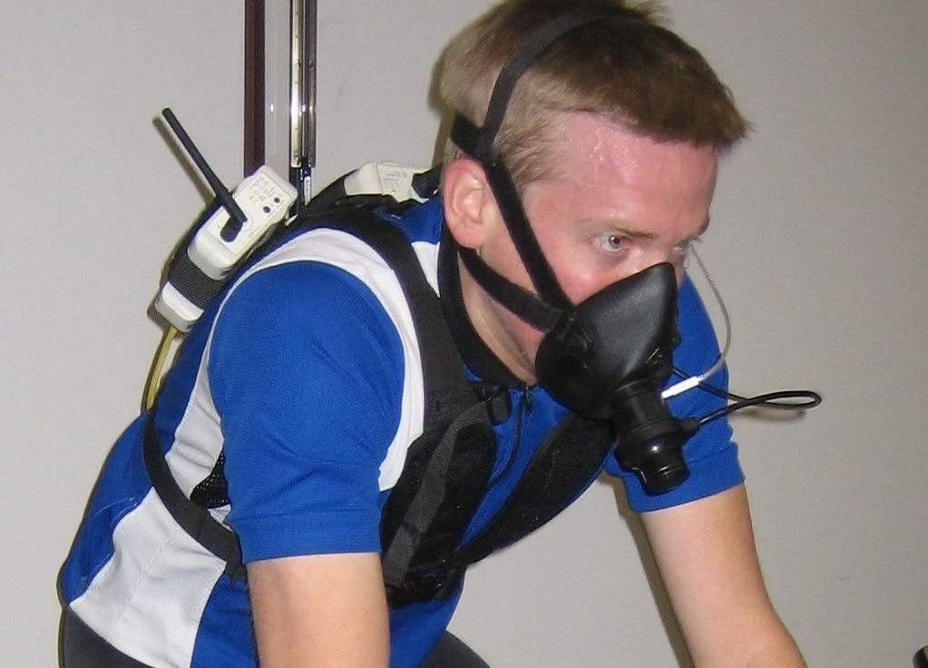
After the fluid drain, they put me on the bike for a quick warmup followed by a four-minute all-out effort. In order to determine what was going on inside my body, they strapped a mask to me to measure the volume and constituents of my breath, and continued to drain my blood to measure lactate levels. I had them take a picture of me, as it was an impressively odd looking setup.


If my eyes looked glazed over and my face looks flushed, it's because I'd had a gas mask strapped to my face starving me of Oxygen for the past 3.5 minutes. I strongly suspect that this 'study' is really just a front, trying to understand how much physiological torture one would willingly undergo with no particular goal in mind.

More on the results later.

Wednesday, January 09, 2008

I'm exhausted.

Whew, time to call it a day.

Saturday, January 05, 2008

Monday, December 10, 2007

Wednesday, November 28, 2007

Poor Decision Making Ability


This past Saturday, while most sane people were digesting leftover turkey sandwiches and standing in line at Best Buy, I used my poor decision making ability (to its fullest), combining inclement weather with unfortunate terrain.

Yes, I decided to ride the 50-mile 'Dirty Dozen', or as the organizer, Danny Chew pleasantly describes it, "A Journey Through Pain"

Now generally speaking, 50-mile rides are mostly easy, 2.5 hour affairs. Not this one. Mr. Chew went specifically looking for the steepest roads in the Pittsburgh region to ride up.

For those of you who don't live in Pittsburgh: steep... means STEEP. As in world-record 37% grade. And unfortunately (or fortunately, depending on your particular brand of masochism), that 37% hill was the easiest of the thirteen.


As per my modus operandi, I came to Pittsburgh ill-prepared; having a 11-21 rear cassette on my bike... basically, my bike wasn't set up to go slow enough for me to be able to still turn the pedals. A $60 penalty imposed by the not-so-local bike shop got me their last 12-27 cassette, and I was back in business. I was to learn later that another unfortunate participant walked in five minutes later to find out I had stolen his cassette from him...

Not really knowing what to expect, I arrived with my entourage (read: mother and sister) to the start with what I thought was a half-hour to spare. Seeing as it was about 40 degrees out, I didn't expect a big turnout.

I was wrong. In all, 130 people showed up. Perhaps due to the extra people, we didn't manage to get started until an hour after I'd arrived; that trend was to continue throughout the day. I *did* manage to balance out my early arrival/late start by managing to be the last person out of the starting gate, though, so all was well in the world.

I didn't think starting last was a big deal, because I was going to take it easy on the first hill and feel out the procedure and hills. It turns out that a whistle is blown at the bottom of the hill, which indicated the (rolling) start; the top ten riders scored points. At the top of the hill everyone would wait for the last rider, and then ride (presumably neutral) to the next hill.

Now, position when that whistle was blown was sometimes irrelevant, and sometimes critical, depending on the turns, road surface, and wet leaves, that all can preclude passing. As I didn't know the route, I was attempting to stay about five-ten people back when the whistle blew; attempts that were, by-and-large, complete failures. On Canton, I was stopped when, not unusually, someone in front of me fell over backwards and started doing somersaults down the hill. Unfortunately this was NOT caught on camera, but still, the antics of other participants bears watching. Fortunately, I am not featured in said video.


Yes, I made it up all of the hills. I scored points on three of them. I was stopped by falling riders on two, automobiles on a third, and a last-minute rule change on a fourth. The others? I was just too lazy, including the last one, where I swore I wouldn't do this again.

I finished in 22nd place, at least, to the extent that '22nd' is a 'place' instead of a 'measure of failure'. I blame the ten pounds I've gained in the last two months.